


Stephen Gadd
-
Posts
9 -
Joined
-
Last visited
Content Type
Profiles
Forums
Gallery
Events
Posts posted by Stephen Gadd
-
-
7 minutes ago, amateur said:
I don't know how it was in the UK, but in the Netherlandse (and other "EU-countries") larges sheets of paper were often/always made with a watermark.
This mark can be quite helpfull in dating the map (at least biy providing a time-fence).
By the looks of the map itself, I would vote for late, rather than early.
Jan
That's a really good point, thank you, but in this case the map is drawn on parchment.
-
Thanks, yes, judging from the correspondence between the Customs Commissioners and the officers here on the Hampshire coast (a smuggling hot-spot from at least as early as 1680), things certainly hotted up after 1750 in terms of volumes and violence. The Customs sloops and yachts were also replaced with cutters from 1752.
-
Thanks! No! 😆
- mtaylor, uss frolick and bruce d
-
 2
2
-
 1
1
-
-
I like your reasoning, Bruce, concerning the demonstration of protection of legitimate commerce. No, there's nothing to suggest that the map was in any sense official: it looks to me as though the manorial steward may simply have engaged the map-making services of one of the locally-stationed customs officers.
-
-
Thank you for your really interesting and detailed reply, Bruce, that certainly does help.
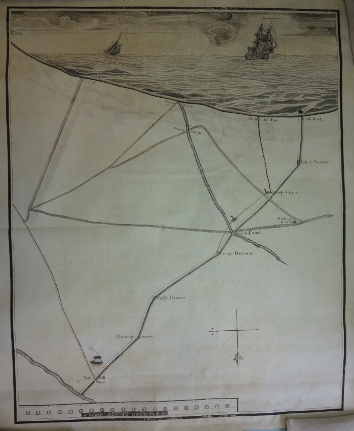
I'm not supposed to share images of the map itself (roughly 18" x 24"), but I don't think the attached low-resolution screenshots give too much away: most of the time and effort has been put into the ship drawings! In that respect I think it's quite unusual, and it's difficult to understand its rationale: my best guess is that it was produced to record pictorially part of a manorial perambulation that was already well known in textual form (this area is now covered by Bournemouth, and records of this boundary survive from the neighbouring manor of Canford from 1540s); but the map is so poorly proportioned and detailed that it adds little or nothing of value in that regard.
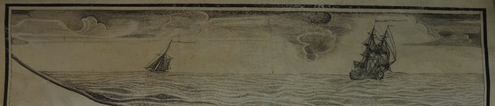
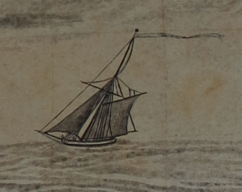
Smuggling was a big problem here at least as early as 1680, and I wonder if either of the vessels are of a type that might have been attached to the customs.
Stephen

-
Hi. I'm trying to date a historical map, and it has been suggested that someone on this forum might recognise particular features of ships drawn on the margin (see below) which might pin the dating down to a particular decade of the 18th century. The map itself (of part of the south coast of England) is very sketchy, and what seems to be an even sketchier copy of it in the same archive collection has accounts scribbled on the back dated 1750.
I'd be interested to know the likely occupation of the depicted ships too.
Thanks in advance for any helpful suggestions!Stephen (on Twitter @docuracy)

Dating 18th-century map from ship drawings
in Nautical/Naval History
Posted
Indeed, it is rather puzzling. It's definitely a landowner's map, from his own archive; there's a scale of furlongs but the distances between the known points are way out, and the most significant building known to have existed here in the 18th century is entirely absent (it appears on a coastal survey of 1714). There was no other building development here until 1807.
The '1750' copy is very rough, and is on paper but without any discernable watermark. The writing on the back appears entirely unconnected with the map itself, being a note of rent collections but not from this district, which suggests to me that by 1750 it was being used as scrap paper. The ships are omitted, but the sections of coastline and estate boundary have compass directions marked; alternative lines for the boundary have been erased, leading me to suspect that if not a draft for the neat version, then it was perhaps a copy of the neat version and made in connection with an unidentified legal case - it has a label 'W1' characteristic of documents produced as evidence. The boundary remained in dispute until 1805.
Anyway, this lack of clarity in other evidence explains why I was hoping that the ship drawings might help!